
 LinkBack URL
 About LinkBacks
Server-side web GIS applications with Leaflet and PostGIS
Video: .mp4 (1280x720, 30 fps(r)) | Audio: aac, 44100 Hz, 2ch | Size: 11.4 GB
Genre: eLearning Video | Duration: 37 lectures (16 hours, 39 mins) | Language: English
Accessing common data stores
What you'll learn
Develop complex web GIS applications using data stored in a PostGIS database with open source software that doesn't require any licensing fees or subscriptions.
Requirements
Basic web development skills (HTML, CSS, and JavaScript)
Basic understanding of web mapping with leaflet
Basic understanding of databases and SQL
The above can be learned in my courses "Display and analyze GIS data on the web" and "PHP registration, login, and content management system"
Highly recommended course: "Introduction to spatial databases with PostGIS and QGIS
Description
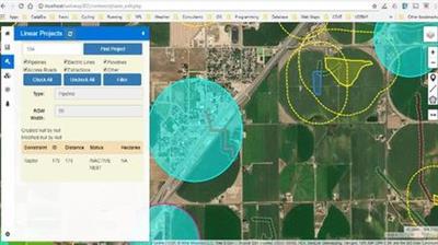
Server-side web GIS applications allow you to access GIS data stored in a multi-user database. This means that your data will always be current and any changes that other users make to the data will be immediately available in your application. You will be able to build complex GIS applications where some users will only be able to view certain data that you allow them and other users will be able to add, edit, and delete data from a web-interface. This means that your users will be able to interact with your GIS database from any device that has a compatible browser and an internet connection. They may be working in the field from a mobile device or from home on a mac OS computer, or on the other side of the world on a Linux computer.
This course uses PHP for the server-side language because of its popularity and its wide availability on web servers. We will use PostGIS as a spatial database, again because of its popularity and common usage in GIS applications. I teach standard web development methods that have stood the test of time and will still be available in many years after the latest, greatest, technology has been replaced with something even better. My goal as an instructor is to provide an introduction to the basic concepts. I don't think you will find any limitations with the software that I teach but if you ultimately decide to use a different server-side language, database, or a newer framework the methods you learn here will provide a solid foundation.
Best of all, this course uses all open source software so there are no costs involved. I have had projects involving more than 50 people, including clients, accessing the same database through web interfaces and desktop GIS for several years with no problem and with no cost other than web-hosting which cost us about $10/month total.
Who this course is for:
GIS professionals who are interested in expanding their skillset from producing static web maps to creating web GIS applications that allow creation and deletion of GIS data from the web.
Download link:Kod:rapidgator_net: https://rapidgator.net/file/81e889e6523cbbe78228e11797401b84/v65uw.Serverside.web.GIS.applications.with.Leaflet.and.PostGIS.part01.rar.html https://rapidgator.net/file/c0d7eadb772706247ca7a7102d7cdd58/v65uw.Serverside.web.GIS.applications.with.Leaflet.and.PostGIS.part02.rar.html https://rapidgator.net/file/8085cfba875a6d2c6d38c8013dfcae10/v65uw.Serverside.web.GIS.applications.with.Leaflet.and.PostGIS.part03.rar.html https://rapidgator.net/file/7e66fb1683e5573c7d5d378555c4e9f5/v65uw.Serverside.web.GIS.applications.with.Leaflet.and.PostGIS.part04.rar.html https://rapidgator.net/file/ef4df6f3a4291f5a0e40a81d2d705a10/v65uw.Serverside.web.GIS.applications.with.Leaflet.and.PostGIS.part05.rar.html https://rapidgator.net/file/474611f8850d3da6b43d7be734486f1c/v65uw.Serverside.web.GIS.applications.with.Leaflet.and.PostGIS.part06.rar.html https://rapidgator.net/file/3f3024f29cd88ad59bec26f0c5c0b522/v65uw.Serverside.web.GIS.applications.with.Leaflet.and.PostGIS.part07.rar.html https://rapidgator.net/file/05497c24936f08cea30dacb6c937cd7b/v65uw.Serverside.web.GIS.applications.with.Leaflet.and.PostGIS.part08.rar.html https://rapidgator.net/file/17770ca6f8aeab2793a45bc1bb4e8e2e/v65uw.Serverside.web.GIS.applications.with.Leaflet.and.PostGIS.part09.rar.html https://rapidgator.net/file/cd38a21ad48bac154ef005705babea67/v65uw.Serverside.web.GIS.applications.with.Leaflet.and.PostGIS.part10.rar.html https://rapidgator.net/file/38866f840b9311060a5dbffd81b27b43/v65uw.Serverside.web.GIS.applications.with.Leaflet.and.PostGIS.part11.rar.html https://rapidgator.net/file/c11d249247f46f2bd1d7b8ea62aa8126/v65uw.Serverside.web.GIS.applications.with.Leaflet.and.PostGIS.part12.rar.html nitroflare_com: https://nitroflare.com/view/8542CAF494FCD9E/v65uw.Serverside.web.GIS.applications.with.Leaflet.and.PostGIS.part01.rar https://nitroflare.com/view/C8A8BBC0DD87BAD/v65uw.Serverside.web.GIS.applications.with.Leaflet.and.PostGIS.part02.rar https://nitroflare.com/view/67D97933D5D549D/v65uw.Serverside.web.GIS.applications.with.Leaflet.and.PostGIS.part03.rar https://nitroflare.com/view/4BED77C0E90A496/v65uw.Serverside.web.GIS.applications.with.Leaflet.and.PostGIS.part04.rar https://nitroflare.com/view/1549BB0003E2AB1/v65uw.Serverside.web.GIS.applications.with.Leaflet.and.PostGIS.part05.rar https://nitroflare.com/view/A13344990636452/v65uw.Serverside.web.GIS.applications.with.Leaflet.and.PostGIS.part06.rar https://nitroflare.com/view/BB499079768DA1A/v65uw.Serverside.web.GIS.applications.with.Leaflet.and.PostGIS.part07.rar https://nitroflare.com/view/5EF5239BCEE09FF/v65uw.Serverside.web.GIS.applications.with.Leaflet.and.PostGIS.part08.rar https://nitroflare.com/view/82D8DDCF0959AE8/v65uw.Serverside.web.GIS.applications.with.Leaflet.and.PostGIS.part09.rar https://nitroflare.com/view/AC93623375030E7/v65uw.Serverside.web.GIS.applications.with.Leaflet.and.PostGIS.part10.rar https://nitroflare.com/view/F8C628DA45976B1/v65uw.Serverside.web.GIS.applications.with.Leaflet.and.PostGIS.part11.rar https://nitroflare.com/view/3C89BD15BCDEE80/v65uw.Serverside.web.GIS.applications.with.Leaflet.and.PostGIS.part12.rarLinks are Interchangeable - No Password - Single Extraction

1 sonuçtan 1 ile 1 arası
-
02.03.2020 #1Üye


")
- Üyelik tarihi
- 20.08.2016
- Mesajlar
- 147.735
- Konular
- 0
- Bölümü
- Bilgisayar
- Cinsiyet
- Kadın
- Tecrübe Puanı
- 157
Server-side web GIS applications with Leaflet and PostGIS


 Alıntı
Konu Bilgileri
Users Browsing this Thread
Şu an 1 kullanıcı var. (0 üye ve 1 konuk)

Konuyu Favori Sayfanıza Ekleyin