
 LinkBack URL
 About LinkBacks
The Autodesk Civil product team has released an update to AutoCAD Civil 3D 2020. This release includes new and updated features, performance enhancements and fixes for Autodesk Civil 3D 2020.
Autodesk AutoCAD Civil 3D 2020.1 (x64) Update | 1.7 Gb
New Features in Autodesk Civil 3D 2020.1
The Autodesk Civil 3D 2020.1 Update contains the following new features and enhancements.
Design Efficiency Updates
- Create, edit, and export rail lines using the new commands on the Rail ribbon tab
- French and German design rules are now available for rail platform edge creation.
- The rail turnout catalog has been extended to include French turnouts based on SNCF standards.
- Use new options for viewing pressure networks in profile view.
- Use the new enhancements in the Analyze Gravity Network command
Production Efficiency Updates
- Use enhanced reference template features to manage styles and settings.
- The Manage Data Shortcuts command has been updated with the features for specifying a different data shortcut project path when the current path is still valid.
- Use a new system variable named PipeNetworkSyncMode to control the synchronization of data referenced pipe networks when you open a host drawing.
Collaboration and Data Exchange Updates
- Use the new features to bring ArcGIS data into your Civil 3D drawings and to save back, publish, and export data for use in ArcGIS.
- Export feature lines to LandXML files and use enhanced methods for importing feature lines from LandXML files.
Other Updates
- The behavior of some of the overlay slope options in the corridor rehab subassemblies has been updated.
- Reports are now available on the Toolbox tab of Toolspace for reporting parcel information in a counter-clockwise direction.
A more comprehensive description of the upgrade may be found in the "Release Notes for Autodesk Civil 3D 2020.1" inhelp.autodesk.online[/url]Kod:https://help.autodesk.com/view/CIV3D/2020/ENU/?guid=Civil3D_ReleaseNotes_2020_1_Release_Notes_html
Autodesk Subassembly Composer
Fixed an issue in which superelevation of subassemblies created from the Subassembly Composer was not incorporated into a corridor.
Improved performance when opening rail subassembly PKT files that use cant.
Corridors
Fixed an issue in which rehab corridor terminology was translated inconsistently.
Data Shortcuts
Fixed an issue in which you could not close the folder selection dialog box when renaming the existing working folder.
Fixed an issue in which data shortcut references would not synchronize correctly.
Fixed an issue in which a data shortcut could be created from an unsaved drawing, which would result in a data shortcut without a source object.
Esri ArcGIS Data Workflows
Improved stability when selecting a feature line that was imported from ArcGIS as a corridor baseline.
Fixed an issue in which a feature line imported from ArcGIS with the same geometry and name as an existing feature line was not renamed.
Export Civil 3D Drawing
Fixed an issue in which multileaders did not explode properly when using the Export Civil 3D Drawing command and exporting to the AutoCAD 2010 drawing version or an earlier drawing version.
Feature Lines
Fixed an issue in which the elevation of a feature line was set to zero when using the AUDIT command.
Fixed an issue in which deleting a curve from a feature line would cause the resulting vertices to have incorrect elevations.
Note: The AutoCAD 2020.1 Update contains a fix for an issue in which feature line glyphs would not appear after using the LAYISO command to isolate a layer in Civil 3D. For more information about the AutoCAD 2020.1 Update, see the AutoCAD 2020.1 Update Release Notes.
Interoperability with Autodesk InfraWorks
Fixed an issue in which a curb and gutter component would be in the wrong orientation when brought into Civil 3D from InfraWorks.
LandXML
Fixed an issue that caused alignments to be added to sites when they were imported from a LandXML file.
Miscellaneous
Fixed an issue in which the AutoCAD 2018 version of DXF was missing from the application menu.
Improved stability when performing a mapcheck analysis on a parcel with curved edges.
Fixed an issue in which frozen layers were improperly displayed in shared views.
Fixed an issue where in some environments, applying customization files caused Civil 3D to close unexpectedly on startup.
Pipe Networks
Fixed an issue in which pipes and structures used the units specified in the pipe network feature settings instead of the units specified in the pipe and structure feature settings.
Fixed an issue in which a pipe centerline that was referenced into a drawing using an xref was displayed using the color of the xref layer.
Fixed an issue where pipe networks that used a style in which only the centerline was displayed in plan view were not visible when the visual style for the drawing was set to Conceptual.
Fixed an issue in which spanning pipe labels could not be moved to new locations along pipes in a plan view.
Fixed an issue in which inlet dimensions were not displayed in a gravity network analysis report.
Points
Fixed an issue in which the point data in a .csv file parsed incorrectly during the point import process when the data contained user defined properties.
Fixed an issue in which the COGO points referenced into a drawing with an xref would update every time the drawing was opened.
Fixed an issue that caused properties on the Query Builder tab of the Point Group Properties dialog box to change after attaching an external reference.
Pressure Networks
Fixed an issue in which replacement parts were not applied properly when swapping pressure parts and an error would be displayed.
Fixed an issue in which pressure network parts were removed unexpectedly from a profile view after using the Delete Part command. This issue would occur in cases where an alignment had been created from the pressure network in the opposite direction of the pressure network.
Fixed an issue in which the location of a pressure network fitting in profile view was incorrect.
Fixed an issue in which the last pressure network fitting was not included when creating an alignment from a pressure network.
Fixed an issue in which a pressure pipe drawn off the end of an existing pipe in profile view using the Profile Layout Tools was added to the opposite end of the existing pipe.
Fixed an issue in which a curved pipe in a pressure network appeared straight in plan view after using the Follow Surface command and then grip editing the pipe in profile view.
Fixed an issue in which changing the reference alignment of a pressure network did not update the pressure network labels.
Fixed an issue in which you could not set the pressure network catalog after applying a custom user profile.
Fixed an issue in which plug and cap fittings were not displayed correctly in a profile view.
Fixed an issue in which pressure pipe fittings on a frozen layer were improperly displayed after using the REGEN command.
Fixed an issue in which pressure pipe fittings were improperly scaled in a profile view when opened in an object-enabled AutoCAD session.
Reference Templates
Fixed an issue in which the saved path of a reference template could not be changed.
Fixed an issue in which the Descriptionted Unit Display Type and Driving Direction in the Ambient Settings were not referenced into a host drawing from a reference template.
Fixed an issue with reference templates in which the Blocks check box on the Other Resource tab could not be cleared when there were no blocks in the collection.
Improved stability when using the preview pane in the Attach Referenced Template dialog box.
Fixed an issue in which grading criteria sets were not displayed in the Attach Referenced Template dialog box.
Fixed an issue in which an attached reference template would overwrite the units in a drawing.
Surfaces
Fixed an issue for volume surface elevation analysis in which an incorrect volume surface was reported when the maximum elevation range was greater than the surface maximum elevation but less than 0.
Fixed an issue where the volume of a volume surface shown in a surface elevation legend table did not match the volume shown in the surface properties.
Fixed an issue where the volume of a volume surface shown in a surface elevation legend table was incorrect when the elevation analysis contained a range with a negative elevation value.
Survey
Fixed an issue in which survey figure data imported incompletely.
Fixed an issue where accessing survey figure properties in model space from within a locked layout viewport would cause the viewport scale to change.
Fixed an issue in which you could not select a network path as the working folder for a survey database.
Traverse Editor
Fixed an issue in which side shots were incorrectly included in a traverse after performing an adjustment.
AutoCAD Civil 3D software from Autodesk addresses the needs of civil engineering companies involved in standalone and BIM (building information modelling) Civil engineering projects.
Built on a familiar AutoCAD platform AutoCAD Civil 3D has been specifically geared to address the challenging needs of civil engineers around the world involved in complex and demanding civil engineering projects such as land development, transportation (for example M25 motorway improvements) and even water based engineering projects.
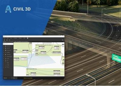
Autodesk Civil 3D 2020 delivers further improvements to performance and scalability, enhancing BIM design and production efficiencies for larger, more complex projects, the company said. New features and the new Dynamo for Civil 3D will streamline repetitive tasks and help users get more out of models. Users can get started with the included sample scripts or use the visual programming environment to develop custom scripts to tackle specific tasks.
In addition to the introduction of Dynamo for Civil 3D, the 2020 version of Civil 3D also comes with notable enhancements to storm and sanitary analysis, gravity network analysis, and an upgraded user interface.
Updated User Interface
The first thing users may notice when launching Civil 3D 2020 is the look and feel - a dark blue theme running across the ribbon background, and easier navigation. These cosmetic updates were designed to create a uniform experience across the entire AEC Collection. Upgrades to the ribbon icons scale with high-resolution monitors such as a 4K display, helping to make the purpose of each command clear and intuitive.
Storm and Sanitary Analysis
There are several updated features in Autodesk Storm and Sanitary Analysis, which accompanies Civil 3D 2020. When analyzing multiple storm events, users can now add separate tailwater conditions for each event and edit the outfall conditions for each storm event. When using dimensionless hydrographs, users can now adjust the peak rate factor for the hydrograph on a per sub-basin basis. For example, if running an SCS hydrology model, TR20 or TR55, the sub-basin dialog box enables a new peak rate factor field at the top of the dialogue box and for each sub-basin in the table at the bottom of the dialogue box. The factor can be entered on either location and copied from one sub-basin to another. New storage chamber systems from ADS or Cultec are available for underground attention.
Gravity Network Analysis
The updated analyze gravity network command helps users analyze a gravity pipe network and then apply the results while in the model. This feature uses the hydraulic properties and gutter details for each structure being analyzed in this network. The wizard for the analyze gravity network command has been replaced with a mode-less dialogue box, which enables users to directly interact inside the drawing. There are three types of analysis to choose from - pipe sizing, computing energy in hydraulic grade lines, and inlet analysis. By selecting the network details button before running the analysis, users can review and resolve issues before performing the final analysis. Additional outfall options have been added to give more design options. View the final results of an analysis in an Excel spreadsheet for reporting.
Civil 3D 2020 - New Features and Updates
Autodesk helps people imagine, design and create a better world. Everyone-from design professionals, engineers and architects to digital artists, students and hobbyists-uses Autodesk software to unlock their creativity and solve important challenges.
Product: Autodesk AutoCAD Civil 3D
Version: 2020.1 Update with Add-ons *
Supported Architectures: x64
Website Home Page :Language: englishKod:http://www.autodesk.com
System Requirements: PC **
Supported Operating Systems: **
Software Prerequisites: Autodesk AutoCAD Civil 3D 2020
Size: 1.7 Gb
- C3D_2020_1_Update.exe
Add-ons for for AutoCAD Civil3D
- Storm and Sanitary Analysis Module for Autodesk Civil 3D 2020
- River and Flood Analysis Module for Autodesk Civil 3D 2020
- Geotechnical Module for Autodesk Civil 3D 2020
- Autodesk Data Extension for 12d 2020
- Autodesk Import-Export Extension for GENIO 2020
- ISYBAU Translator for Autodesk Civil 3D 2020
- Microdrainage Utility for Autodesk Civil 3D 2020
- Dynamo for Autodesk Civil 3D 2020
- Inventor Infrastructure Modeler Plugin 2020
- Infrastructure Parts Editor 2020
System requirements for Civil 3D 2020
Operating System
- Microsoft Windows 7 SP1 with Update KB4019990 (64-bit only)
- Microsoft Windows 8.1 with Update KB2919355 (64-bit only)
- Microsoft Windows 10 (64-bit only) (version 1803 or higher)
Browser Google Chrome (for AutoCAD web app)
Processor
Minimum: 2.5-2.9 GHz or faster processor
Recommended: 3+ GHz or faster processor
Memory 16 GB
Display Resolution
Conventional Displays:
1920 x 1080 with True Color
High Resolution & 4K Displays:
Resolutions up to 3840 x 2160 supported on Windows 10, 64 bit systems (with capable display card)
Display Card Minimum: 1 GB GPU with 29 GB/s Bandwidth and DirectX 11 compliant
Recommended: 4 GB GPU with 106 GB/s Bandwidth and DirectX 11 compliant
Disk Space 16 GB
Pointing Device MS-Mouse compliant
File Format Changes AutoCAD .DWG format - R2018
Civil 3D Object format - R2018.2*
* New vertical curve profile entities (fixed vertical curve by high or low point) are not supported in Civil 3D 2018.
.NET Framework .NET Framework Version 4.7
Additional Requirements for large datasets, point clouds, and 3D modeling
Memory 16 GB RAM or more
Disk Space 6 GB free hard disk available, not including installation requirements
Display Card 1920 x 1080 or greater True Color video display adapter; 128 MB VRAM or greater; Pixel Shader 3.0 or greater; Direct3D-capable workstation class graphics card.
Download link:Kod:rapidgator_net: https://rapidgator.net/file/8e7681c1833c58e960aedb40bc007db2/9opo8.Autodesk.AutoCAD.Civil.3D.2020.1.Update.part1.rar.html https://rapidgator.net/file/35fd63ccdb2476d1e6677b3a981c6a51/9opo8.Autodesk.AutoCAD.Civil.3D.2020.1.Update.part2.rar.html https://rapidgator.net/file/6acbbcdf9a484982d05d258bb3473b8b/9opo8.Autodesk.AutoCAD.Civil.3D.2020.1.Update.part3.rar.html https://rapidgator.net/file/15e391f5aaf9dec7a0aa5fe96e23fac1/9opo8.Autodesk.AutoCAD.Civil.3D.2020.1.Update.part4.rar.html https://rapidgator.net/file/6773b8246841e072fc0a15ac42151983/9opo8.Autodesk.AutoCAD.Civil.3D.2020.1.Update.part5.rar.html https://rapidgator.net/file/458af04dcb23235db89101fd610ff71e/9opo8.Autodesk.AutoCAD.Civil.3D.2020.1.Update.part6.rar.html nitroflare_com: https://nitroflare.com/view/D4CD2C368E8C7AC/9opo8.Autodesk.AutoCAD.Civil.3D.2020.1.Update.part1.rar https://nitroflare.com/view/7D723F21DD03545/9opo8.Autodesk.AutoCAD.Civil.3D.2020.1.Update.part2.rar https://nitroflare.com/view/9213479BEE57AEB/9opo8.Autodesk.AutoCAD.Civil.3D.2020.1.Update.part3.rar https://nitroflare.com/view/4BF0962DC61D639/9opo8.Autodesk.AutoCAD.Civil.3D.2020.1.Update.part4.rar https://nitroflare.com/view/B65E380932DF33F/9opo8.Autodesk.AutoCAD.Civil.3D.2020.1.Update.part5.rar https://nitroflare.com/view/090A9B6A426D86A/9opo8.Autodesk.AutoCAD.Civil.3D.2020.1.Update.part6.rarLinks are Interchangeable - No Password - Single Extraction

1 sonuçtan 1 ile 1 arası
-
09.09.2019 #1Üye


")
- Üyelik tarihi
- 20.08.2016
- Mesajlar
- 148.593
- Konular
- 0
- Bölümü
- Bilgisayar
- Cinsiyet
- Kadın
- Tecrübe Puanı
- 158
Autodesk AutoCAD Civil 3D 2020.1 (x64) Update


 Alıntı
Konu Bilgileri
Users Browsing this Thread
Şu an 1 kullanıcı var. (0 üye ve 1 konuk)

Konuyu Favori Sayfanıza Ekleyin