
 LinkBack URL
 About LinkBacks
Genre: eLearning | MP4 | Video: h264, 1280x720 | Audio: aac, 44100 Hz
Language: English | VTT | Size: 2.15 GB | Duration: 4.5 hours
What you'll learn
Fully understand the basics of Land use and Land Cover (LULC) Mapping and Change Detection
Get an introduction and fully understand to Remote Sensing relevant for LULC mapping
Learn the most popular open-source GIS and Remote Sensing software tools (QGIS, SCP)
Pre-process and analyze raster in QGIS
Learn about supervise and unsupervised learning and their applications in GIS
Learn how to obtain satellite data, apply image preprocessing, create training and validation data in QGIS
Apply Machine Learning image classification and change detection in SCP and QGIS
Create your first LULC map for your report
You'll also have plenty of handy hints and tips will be provided alongside the code to prevent glitches
You'll have a copy of the practicals step-by-step manuals used in the course for your reference to use in for their analysis
Requirements
An interest in working with geospatial data
A working computer
* The course will be demonstrated using a QGIS version of Windows PC. Mac and Linux users will have to adapt the instructions to their operating systems.
Description
Do you need to design a land use/land cover map for your project but you don't know how to do this?
Do you find GIS books & manuals too not practical and looking for a course that takes you by hand, teach you all the concepts, and get you started on a real-life LULC mapping project?
I'm very excited that you found my LULC CORE course. My course provides you with all the necessary knowledge and skills to implement PRACTICAL, real-life spatial LULC mapping and change detection tasks in popular and FREE software tools.
This course is designed to equip you with the theoretical and practical knowledge of Land Use and Land Cover (LULC) mapping, which is one of the core skills for any Geographic Information Systems (GIS) and Remote Sensing analyst. By the end of the course, you will feel confident and completely understand all theoretical and PRACTICAL background of LULC mapping and Change Detection that you will be able to carry out on the real data in one of the most popular GIS software which is QGIS.
In the course, you will be able to learn how to carry out all stages of LULC mapping from acquiring satellite data to assessing the accuracy of your map and design a beautiful change map readily available to be inserted in your document or report.
The course is ideal for professionals such as geographers, programmers, social scientists, geologists, and all other experts who need to use LULC maps in their field and would like to learn fundamentals of LULC and change detection in GIS. If you're planning to undertake a task that requires to use a state of the art classification algorithms for creating, for instance, land cover and land use maps, this course will give you the confidence you need to understand and solve such geospatial problem.
One important part of the course is the practical exercises. You will be given some precise instructions and datasets to create LULC maps and change maps using the QGIS software.
In this course, I include downloadable practical materials that will teach you:
- How to install open source GIS software on your computer and correctly configure it
- QGIS software interface including its main components and plug-ins
- Learn how to classify satellite images with different machine learning algorithms in QGIS
- Learn how to perform training, validation data collection and accuracy assessment
- Learn how to perform change detection with the Semi-automated classification plug-in
- Learn how to prepare your first land cover change map for your report
Who this course is for:
Geographers, Programmers, geologists, biologists, social scientists, or every other expert who deals with GIS maps in their field
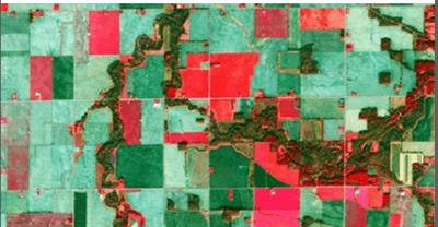
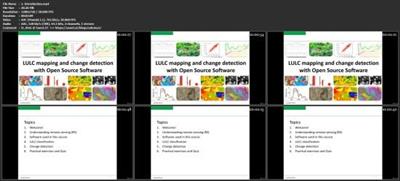
Screenshots
Download link:Kod:rapidgator_net: https://rapidgator.net/file/4e4283713351c927d746f34d40df73f5/5vw3q.Core.GIS.Land.Use.and.Land.Cover..Change.Detection.in.QGIS.part1.rar.html https://rapidgator.net/file/9dc36abdd1b4a8113b7bdc8d592f4282/5vw3q.Core.GIS.Land.Use.and.Land.Cover..Change.Detection.in.QGIS.part2.rar.html https://rapidgator.net/file/6b3f145d3d2751ef18e143dc020da4ff/5vw3q.Core.GIS.Land.Use.and.Land.Cover..Change.Detection.in.QGIS.part3.rar.html nitroflare_com: https://nitroflare.com/view/20B70BC33CD0D15/5vw3q.Core.GIS.Land.Use.and.Land.Cover..Change.Detection.in.QGIS.part1.rar https://nitroflare.com/view/7F69CA8CD752CBE/5vw3q.Core.GIS.Land.Use.and.Land.Cover..Change.Detection.in.QGIS.part2.rar https://nitroflare.com/view/43653E43F49089B/5vw3q.Core.GIS.Land.Use.and.Land.Cover..Change.Detection.in.QGIS.part3.rarLinks are Interchangeable - No Password - Single Extraction

1 sonuçtan 1 ile 1 arası
Threaded View
-
13.05.2020 #1Üye


")
- Üyelik tarihi
- 20.08.2016
- Mesajlar
- 150.962
- Konular
- 0
- Bölümü
- Bilgisayar
- Cinsiyet
- Kadın
- Tecrübe Puanı
- 160
Core GIS Land Use and Land Cover & Change Detection in QGIS


 Alıntı
Konu Bilgileri
Users Browsing this Thread
Şu an 1 kullanıcı var. (0 üye ve 1 konuk)

Konuyu Favori Sayfanıza Ekleyin