
 LinkBack URL
 About LinkBacks
(x86/x64)English | File size: 12.2 / 14 MB
GreatCirc is a tool for calculating Great Circle distances on the earth's surface, and plotting points and great circle paths on a world map.
The "great circle path" is the shortest direct route between two points on the earth's surface. Because the earth is a globe, the shortest path between any two points lies on a circle which is centred at the earth's core and passes around the surface of the world. Such a path will appear to be a curved line when drawn on a flat world map because of the distortion inherent in mapping the globe onto a flat map.Great Circle Distance calculation: find the shortest distance and direction between two points. (example)
Great Circle End Point calculation: find the end point of a great circle path, given start, distance and direction.
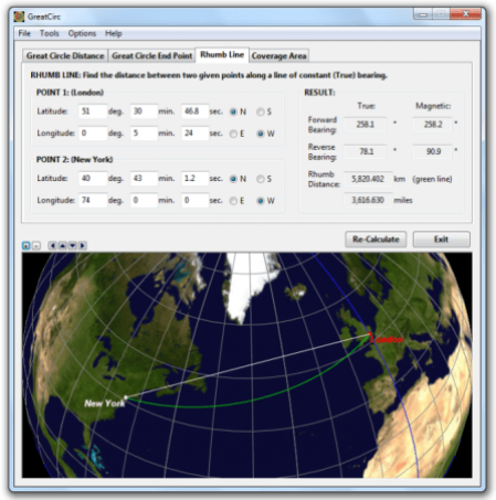
Rhumb Line Calculation: find the distance between two points along a line of constant bearing.
Enter map points by clicking on the world map. Left-click for Point 1, right click for Point 2.
Choose map points from a built-in list of Major Cities.
Enter map points using Australian Map Grid (AMG) coordinates.
Perform calculations using a simple spherical earth model, or the WGS84 standard ellipsoid.
Lite Features:
Improvements to the installer, especially when installing in multi-user environments.
Improved un-installer access for Windows 8 and above.
Improved animated wait cursor for Windows 7 and later.
Added "Check for Updates" option in Help menu.
Pro Features:
Batch Mode has been removed from the File menu. MapList-Flat and MapList-Globe apps now provide this functionality.
The option to save a Batch Report of multiple Great Circle calculations to a single report file is still provided, and is now available via the main File Menu.
Save Image now allows a selection of image file types, not just BMP.
Save Report and Batch Report now include the option of saving to PDF format. The single calculation PDF report includes both the report table seen in the HTML report, as well as the current map image, all together on the one PDF page.
Minor improvements to formatting of HTML report.
GreatCirc now suggests descriptive filenames for saved images, paths, and reports, based on calculation type and point locations.
The Magnetic Azimuth dialog, now includes site names, as per main dialog, if applicable.
Bug Fixes & Other Refinements:
Fixed bug where clicking on zoomed Globe view selected incorrect lat,long point when near edge of globe.
DOWNLOAD
uploadgig
rapidgatorKod:https://uploadgig.com/file/download/5940463A656C559b/wa5NMY5u_GreatCirc_3.rar https://uploadgig.com/file/download/1cBb87eE1EBb6dad/wa5NMY5u_GreatCirc_3_.rar
nitroflareKod:https://rapidgator.net/file/fc4b29ec7c3b2a8aa4aaf9b40b73e05a/wa5NMY5u_GreatCirc_3.rar https://rapidgator.net/file/38312522eeeece85fc7d13c53a45d653/wa5NMY5u_GreatCirc_3_.rar
Kod:http://nitroflare.com/view/42BCCD8CEB656A8/wa5NMY5u_GreatCirc_3.rar http://nitroflare.com/view/B43405B4FFEDB28/wa5NMY5u_GreatCirc_3_.rar

1 sonuçtan 1 ile 1 arası
-
09.01.2020 #1Üye


")
- Üyelik tarihi
- 17.12.2018
- Mesajlar
- 28.592
- Konular
- 0
- Bölümü
- Gıda
- Cinsiyet
- Erkek
- Tecrübe Puanı
- 34
Gunamoi GreatCirc 3.3 (x86/x64)


 Alıntı
Konu Bilgileri
Users Browsing this Thread
Şu an 1 kullanıcı var. (0 üye ve 1 konuk)

Konuyu Favori Sayfanıza Ekleyin